
USC Wetland Team
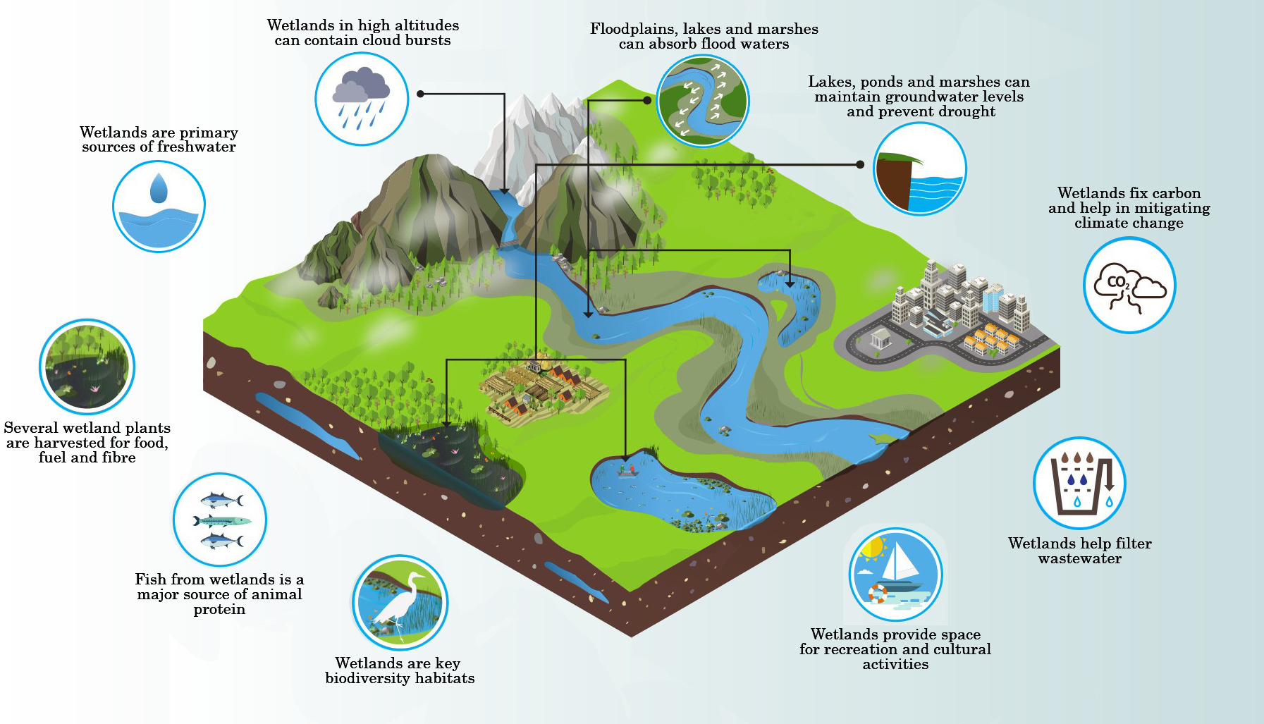
Our Wetland Team delivers wetland conservation on a watershed scale. Many people recognize wetlands provide nutrient and runoff retention as well as habitat, but their benefits are often overlooked across the watershed. For that reason our team is dedicated to increasing wetland restoration and expanding wetland education and understanding across our region. We support many wetland-related programs, providing site review, monitoring, design, construction and maintenance to partners, members and other USC teams alike.
Wetland Team Goals
- Continue working to increase wetland restoration across the watershed with emphasis on projects that meet CBP model BMP reporting standards.
- Expand wetland education efforts through increased participation in public outreach events, and develop age-appropriate outreach materials for those events.
Targeted 2024 Projects
- Identify additional wetland needs in the watershed
- Initiate targeted wetland outreach
- Develop Chesapeake Bay Wetlands Action Strategy for New York
- Construct USC Water Quality Program wetland restoration projects – sites already identified and others as they come in.
- Continue assisting USC Teams and Partners with construction and maintenance needs.
As we increase our efforts to identify potential wetland restoration sites across the watershed, we plan to develop resources to better assist our partners in finding those sites. Below are some GIS datalayers for use by our partners in reviewing potential work areas.
The following are raster files for each New York USC County. These files are general locations of suitable soils and slopes using coarse data available on a region-wide scale.
Watershed-wide data layers |
| USC Watershed Member County: Soil Drainage Class Layer |
| USC Watershed Member County: Digital Elevation Model (DEM) Layer |
Other wetland datalayers available online
NWI Wetland Data can be downloaded here: https://www.fws.gov/wetlands/data/data-download.html
NWI Wetland Data available in Google Earth
Soils data available: https://websoilsurvey.sc.egov.usda.gov/App/HomePage.htm
DEC Regulated Wetland Data can be downloaded here: https://cugir.library.cornell.edu/catalog/cugir-008187?id=111
Online Mappers – useful in evaluating potential wetland restoration sites
USDA Web Soil Survey – IMS of digital soil survey data with aerial photos or USGS Topo maps as the background image.
USDA Plants Database – excellent resource for identifying wetland plants and plant indicator status.
Google Maps – google maps regularly updates their aerial photos, often having recent photos for areas across the watershed.
Google Earth – google maps in addition to having updated aerial photos, has the option of toggling through historic aerial photos, as useful tool in site review.
New York Specific Links
NYS OPRHP SHPO IMS – a lot of acronyms for an online mapper that shows the NYS Archaeologically Sensitive Areas.
NYS DEC Environmental Resource Mapper – IMS of the State Regulated wetlands and adjacent “Wetland Checkzone.”
New York iMapInvasives – New York State’s on-line, all-taxa invasive species database and mapping tool for documenting and sharing invasive species observations.
New York Flora Atlas – a source of information for the distribution of plants within the state of New York.
Environmental Concern – Wetland delineation
Rutgers Office of Continuing Professional Education – Wetland training courses
The Swamp School – Field and online-based wetland training
Richard Chinn Environmental Training, Inc. – Wetland delineation training and wetland training since 1994
Institute for Wetland & Environmental Education & Research – providing high-quality technical training to professionals in the field of environmental sciences
Wetland Training Institute – Online and In-person wetland training courses throughout the United States
Some Characteristics of A Wetland Site with High Restoration Potential:
- an interested landowner who appreciates the ecological and/ or watershed benefits of wetlands
- physical properties of the site including:
- low slopes
- “heavy” soils with little sand and gravel content
- physical properties should not include
- high quality existing wetland features including shrub, forested, or wet meadow wetlands without obvious degradation
- a stream with the objective of creating an impoundment
- access for heavy equipment
- ditching or evidence of on site tile in a fallow area
- Funding is unavailable through other government programs
- Ducks Unlimited – Greenwing Page
- Project WET – Educational Resources
- Society of Wetland Scientists – Education & Outreach page
- US EPA – Wetlands Education for Students and Teachers
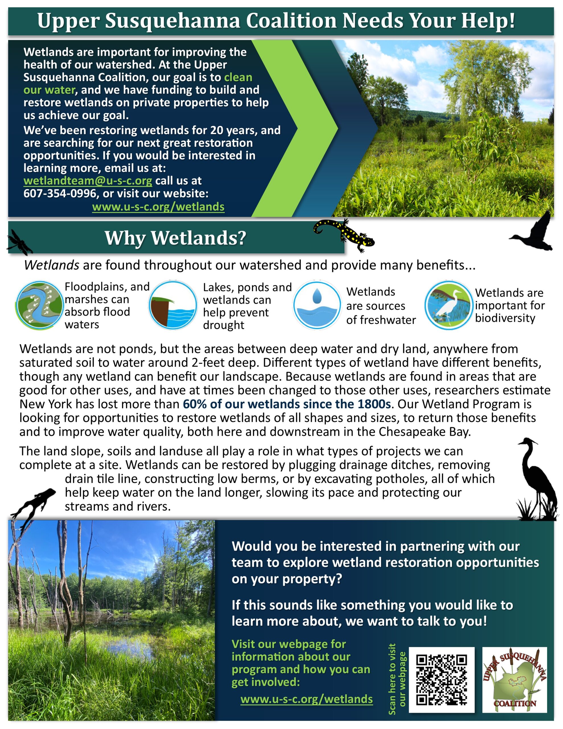
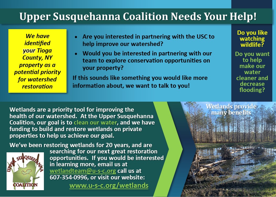
Contact the USC Wetland Team for more information: by email wetlandteam@u-s-c.org or by phone 607-354-0996
Wetland Team Events
Wetland Team News

Upper Susquehanna Coalition Honored for Work in Agriculture
Submitted By: Troy Bishopp Madison County SWCD Albany, NY---Earth Day 2021 received a helping hand from your family
Introducing Our Customers!
With remote learning and connecting so high on everyone's radar, the USC Outreach Team decided that